
Category:National Oceanic and Atmospheric Administration images
| To place a file in this category, add the tag {{PD-USGov-DOC-NOAA}} to the bottom of the file's description page. If you are not sure which category a file belongs to, consult the file copyright tag page. If this category is very large, please consider placing your file in a new or existing subcategory. Free files can be moved to the Wikimedia Commons. |
Media in category "National Oceanic and Atmospheric Administration images"
The following 134 files are in this category, out of 134 total.
-
 3D model of wreck of paddle steamer Niagara.PNG 889 × 464; 445 KB
-
 2024 Lake Ontario National Marine Sanctuaary map with shipwrecks.PNG 1,145 × 644; 1.18 MB
-
 2024 Lake Ontario National Marine Sanctuary map.PNG 1,085 × 831; 1.42 MB
-
 Arctic Ice Shift Graph.png 630 × 429; 39 KB
-
 Barge Helvetia sonar image of wreck.PNG 707 × 927; 548 KB
-
 Bubblegum coral on Santa Lucia Bank.PNG 1,179 × 663; 1.96 MB
-
 Buoy operations Thunder Bay National Marine Sanctuary.PNG 559 × 317; 380 KB
-
 Canal schooner Floretta sonar image of wreck.PNG 714 × 922; 739 KB
-
 Cape Cojo Anchorage.PNG 1,330 × 743; 1.65 MB
-
 Children ROV Wisconsin Shipwreck Coast National Marine Sanctuary.PNG 1,146 × 863; 2.38 MB
-
 Children tie knots at Wisconsin Shipwreck Coast National Marine Sanctuary.PNG 1,151 × 648; 2.06 MB
-
 Daybeacon chart2.png 326 × 219; 7 KB
-
 Divers film wreck of schooner St. Peter in Lake Ontario 13 June 2019.PNG 639 × 969; 1.21 MB
-
 Dominic07-04-19820830ZBD.jpg 413 × 417; 19 KB
-
 Dora1964rain.gif 874 × 865; 838 KB
-
 Earl1992rain.gif 744 × 899; 15 KB
-
 Edouard 96 Atl vis2a.jpg 650 × 460; 183 KB
-
 Erenstoradarestimatepa.PNG 598 × 537; 73 KB
-
 Ernest Lester Jones American Legion plaque.jpg 800 × 518; 283 KB
-
 Fay intensifies over land.jpg 720 × 480; 82 KB
-
 Feuillee.jpg 310 × 369; 25 KB
-
 GeorgeRice-Greenland-1881.jpg 800 × 654; 284 KB
-
 Gosford wreck.PNG 301 × 254; 210 KB
-
 Grampus off Gloucester.PNG 985 × 578; 552 KB
-
 GulfofMexico3D- - 83d40m - locate Sarasota.PNG 734 × 600; 1.05 MB
-
 Humpback whale breaching.PNG 1,560 × 966; 3.3 MB
-
 Humpback whale tail.PNG 303 × 249; 207 KB
-
 Illustration of NOAAS Discoverer (2024).PNG 1,527 × 746; 274 KB
-
 Intense Nor'Easter over the N. Alantic on Mar 26, 2014.png 685 × 568; 605 KB
-
 Ione1955filledrainblk.GIF 740 × 921; 22 KB
-
 Isaac02-03-19821130ZBD.jpg 398 × 572; 28 KB
-
 Island of Oahu - Landsat mosaic.jpg 600 × 531; 42 KB
-
 Jalama Beach.PNG 1,450 × 967; 2.93 MB
-
 John J. Brice.PNG 428 × 597; 203 KB
-
 Karl 9 21 04.JPG 726 × 819; 81 KB
-
 Kate(03)-Track.gif 803 × 634; 67 KB
-
 Katrinavisloop-300x225.gif 720 × 540; 5.48 MB
-
 Kelp forest Cojo Anchorage.PNG 1,455 × 967; 3.03 MB
-
 Kirsten1974satelliteimage.jpg 320 × 298; 101 KB
-
 Lady-Franklin-Bay-explorers1881.jpg 800 × 551; 225 KB
-

-

-
 Lake Ontario National Marine Sanctuary Sanctuary Advisory Council poses with map.PNG 1,146 × 644; 2.07 MB
-
 Lammermoor at anchor.jpg 475 × 324; 24 KB
-
 Leslie rain totals.PNG 849 × 869; 40 KB
-
 Line2742.jpg 1,801 × 1,112; 1.62 MB
-
 Looking down on the seaside suburb of Sumner from the surrounding hills.jpg 1,800 × 1,184; 1.19 MB
-
 Lorenzo (2001)-Evening of 10-30.gif 642 × 482; 343 KB
-
 Lt. Raymond Zussman (FS-241).JPG 622 × 418; 35 KB
-
 Mallows Bay-Potomac River NMS kayaker shipwrecks.PNG 814 × 452; 972 KB
-
 Mallows Bay-Potomac River NMS map.PNG 685 × 520; 701 KB
-
 Maritime heritage display Oswego, New York.PNG 299 × 249; 148 KB
-
 Marshal Mars today.jpg 1,600 × 1,200; 190 KB
-
 MicroscopicShell IceAge.jpg 768 × 512; 25 KB
-
 Milner Baily Schaefer.JPG 352 × 400; 24 KB
-
 Minio Vallis Hanging Valley.JPG 184 × 466; 11 KB
-
 Niagara shipwreck paddle wheels.PNG 751 × 499; 756 KB
-
 Nicholas H. Heck on deck.jpg 1,620 × 1,048; 348 KB
-
 Nicholas H. Heck.jpg 1,036 × 1,596; 179 KB
-
 NOAA Corps officers pose with NOAAS Oceanographer February 2024.PNG 712 × 535; 859 KB
-

-
 NOAA schematic of the Great Lakes.png 447 × 430; 147 KB
-
 NOAAS Oceanographer (2024) illustration starboard side.PNG 769 × 377; 179 KB
-
 Noel Oct 1995.png 371 × 400; 230 KB
-
 North Pole Melts Aug 7 2010.gif 1,024 × 576; 404 KB
-
 Oscar Elton Sette.JPG 577 × 860; 63 KB
-
 Pensacola13.jpg 1,280 × 854; 707 KB
-
 Pensacola14.jpg 1,280 × 854; 875 KB
-
-
 Point Conception Light.PNG 295 × 250; 134 KB
-
 Point Conception Lighthouse on bluff.PNG 1,440 × 964; 2.97 MB
-
 PointUdall-Millennium.jpg 1,764 × 1,156; 1.38 MB
-
 Pomptonriver04162007.png 600 × 465; 17 KB
-

-
 Pyrocumulus.jpg 294 × 447; 18 KB
-

-
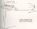 Radio acoustic ranging and echo sounder graphic.JPG 871 × 698; 69 KB
-
 Radio acoustic ranging bomb prep.JPG 748 × 724; 70 KB
-
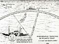 Radio acoustic ranging graphic.jpg 600 × 452; 74 KB
-
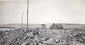 Radio acoustic ranging shore station San Clemente 1925.jpg 500 × 266; 42 KB
-
 Radioman radar acoustic ranging..JPG 1,205 × 697; 135 KB
-
 Rear Admiral Chad M. Cary.jpg 587 × 697; 36 KB
-
 River eroding volcanic ash flow Alaska Southwest, Valley of Ten Thousand Smokes.jpg 1,164 × 1,788; 1.19 MB
-
 Robert F. A. Studds on Elsie III.jpg 700 × 1,071; 57 KB
-
 Robert Francis Anthony Studds.JPG 192 × 216; 31 KB
-
 Robert J. Walker wreath toss.jpg 1,942 × 1,554; 1.24 MB
-
 Robert Mayer White.jpg 700 × 993; 135 KB
-
 Ruth-Sarah-Thelma-Vera on August 23rd,1962.JPG 676 × 497; 21 KB
-
 RV Bay Hydro II.PNG 1,151 × 888; 1.82 MB
-
 RV George B. Kelez USFWS logo on stack.JPG 615 × 939; 67 KB
-
 RV George B. Kelez.JPG 622 × 444; 36 KB
-
 RV John R. Manning (FWS 1002) purse-seining.JPG 1,439 × 949; 180 KB
-
 RV John R. Manning (FWS 1002).JPG 638 × 461; 49 KB
-
 RV Oregon (FWS 1600).JPG 1,105 × 736; 128 KB
-
 Santa Maria River estuary at Rancho Guadalupe Dunes Preserve.PNG 1,444 × 956; 2.06 MB
-
 Schooner Advance sonar image of wreck.PNG 710 × 925; 781 KB
-
 Schooner Gallinipper sonar image of wreck.PNG 711 × 930; 1.03 MB
-
 Schooner Hetty Taylor sonar image of wreck.PNG 711 × 928; 829 KB
-
 Schooner Home sonar image of wreck.PNG 715 × 934; 663 KB
-
 Schooner Rouse Simmons sonar image of wreck.PNG 442 × 578; 262 KB
-
 Schooner Walter B Allen sonar image of wreck.PNG 714 × 924; 686 KB
-
 Schwenter.jpg 196 × 298; 18 KB
-
 Scow schooner Silver Lake sonar image of wreck.PNG 710 × 929; 540 KB
-
 Screenshot 2024-07-14 10.13.39 PM.png 612 × 390; 255 KB
-
 SE-USshoreline.jpg 500 × 409; 50 KB
-
 Sea grant.jpg 182 × 124; 5 KB
-
 Sea otter kelp forest Chumash Heritage National Marine Sanctuary.PNG 1,490 × 962; 2.94 MB
-
 Seabirds.jpg 700 × 465; 64 KB
-
 SeaIce-Sept162012 HR.jpg 1,440 × 770; 502 KB
-
 Seattle waterfront, 1912.JPG 1,802 × 566; 143 KB
-
 Selah Chamberlain archaeologist stern.PNG 594 × 395; 300 KB
-
 Selwyn tir.gif 1,000 × 666; 241 KB
-
 Sep1938rain.gif 920 × 924; 29 KB
-
 SS San Pedro wreck.PNG 1,157 × 652; 1.96 MB
-
 St. Peter shipwreck bowsprit color.PNG 1,441 × 955; 2.05 MB
-
 St. Peter shipwreck bowsprit.PNG 1,443 × 968; 1.42 MB
-
 St. Peter shipwreck deck.PNG 1,450 × 967; 2.81 MB
-
 St. Peter shipwreck diver light.PNG 1,446 × 965; 3.03 MB
-
 St. Peter shipwreck diver swims along wreck.PNG 1,446 × 966; 2.31 MB
-
 St. Peter shipwreck divers investigate.PNG 1,452 × 969; 2.71 MB
-
 St. Peter shipwreck two divers.PNG 1,445 × 965; 2.56 MB
-
 Steam barge Selah Chamberlain sonar image of wreck.PNG 714 × 933; 611 KB
-
 Steamer Robert C Pringle sonar image of wreck.PNG 439 × 576; 405 KB
-
 Steamer Vernon sonar image of wreck.PNG 708 × 930; 724 KB
-
 Stern of Grampus Captain Adams steering.PNG 993 × 789; 646 KB
-
 Stern of Grampus.PNG 990 × 716; 800 KB
-
 Subtropical Cyclone Jan 2009.PNG 523 × 553; 557 KB
-
 TechDiving NOAA Small.jpg 297 × 297; 48 KB
-
 Theb1564.jpg 900 × 1,356; 842 KB
-
 Thousands of fur-seals on a St. Paul beach - a fur seal rookery.jpg 1,772 × 1,152; 1.31 MB
-
 Tibbetts Point Light.PNG 1,640 × 967; 3.87 MB
-
 Tug Henry Gust sonar image of wreck.PNG 711 × 929; 717 KB
-
 Welder Thoma-Sea NOAAS Oceanographer 15 June 2024.PNG 931 × 695; 1.13 MB
-
 Wreck of MV Nordmeer Lake Huron.PNG 657 × 257; 283 KB


.PNG)


-Track.gif)


-Evening_of_10-30.gif)
.JPG)


_and_NOAAS_Discoverer_(2024).PNG)

_illustration_starboard_side.PNG)


.gif)


_purse-seining.JPG)
.JPG)
.JPG)


